Public access to the water is never a matter of applying logic and reason to existing laws. There are a variety of social and economic reasons for this (mainly because wealthy entities are often the owners of valuable water adjacent land), so pretty much every case ends up being considered separately.
Public access to the Chesapeake Bay in Maryland, for example, is a hot mess. I can fish from a boat and cast my lure under your dock on private property, but I cannot stand between the high tide - low tide lines on the shoreline of private property. And street ends are generally considered public property, providing public access to the tidal Bay. Except when they're considered private property, for whatever legitimate or illegitimate reasons.
I had a front row seat to watch a dispute between Florida Rock, which had a gravel mining operation near a colonial era public landing, and the community, which was trying to use the public landing to shut down the gravel mine. Ultimately, the community used the public landing and some ancient Indian burial sites in the area and managed to shoo Florida Rock away. But in that case it was Goliath vs. Goliath, since the community consisted of very well connected waterfront property owners who pooled their resources to hire some very high powered lawyers.
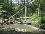
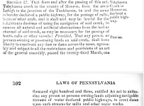
In the Tobyhanna case, it should be straightforward if the creek at any point in history had been designated navigable. But it won't happen without a court fight comparable to the nearby battle royale over the Lehigh upriver from Francis Walter Lake (see
Lehigh Falls Fishing Club 1337 vs. Andrejewski). The appeals court (final) decision is a pretty easy read, though boring. It declared the section of river navigable, and the fishing club packed up and left.
Meanwhile, in New York, there's the matter of the Salmon River, which had been considered navigable, but was then ruled to be not open to the public for fishing. At all. (See
Douglaston Manor vs. Bahrakis) The New York court reached into some pretty obscure areas to find legal justification to support the owners of Douglaston Manor in excluding public access from the navigable waterway. In this case, it's worth noting that Douglaston Manor was established by H. Douglas Barclay, who was in the New York Senate when the Salmon River hatchery was being considered by the legislature. Once he knew the hatchery was going to be built, he bought property and easements along the river with the intention of establishing a private fishery made possible by fish stocked using public money. His venture was, and continues to be, financially successful, in large part because he prevailed in the Douglaston Manor vs. case. In that case, it was Goliath (Douglaston) vs. David, but David got crushed.
By way of footnote, Sen. Barclay ended up being close friends with Prez George Bush I (H.W.), and served as his ambassador to El Salvador. His son, William A. Barclay, who is also one of his heirs, served in the New York Assembly from 2003 through the end of his current term. He is also one of the family members who owns Barclay Outdoors - Douglaston Salmon Run.
Bottom line: You want to fish the Dream Mile on the Tobyhanna? Buy a membership or spend a like amount or more fighting in court to have the area declared open to public fishing by virtue of being navigable. And if you go to court, you may end up losing the fight.
Justice often sides with the person who has the biggest lawyers with the biggest fees.
And if the Dream Mile goes away, all those stocked trout will go away too, so it's appeal as a forbidden fruit fishery may be diminished.
I'd like to say there's another, more idealistic, answer, but it's really all about money.