Recent Rain

Just wondering, having only ever had a public sewage service line, but having reviewed general septic system and sand mound designs, under these wet circumstances do you have to concern yourself about toilet water having a place to go in your drain field? I assume your comment was really about having a full well/worry-free water supply at the moment. I have had a well to think about and understand the relief of a high water table following a drought.

We live on a hilltop above a stream, have a drain field and our soil is extremely rocky and perks like nobody's business. We've never had standing water anywhere on our property (except down by the creek which is far from the house) and I don't even have or need a sump pump because my basement stays bone dry no matter what.

I have to say with empathy for those that suffer under these conditions, it sure is nice to not worry about heavy rainfall, just about drought conditions and whether our well is OK.

If it makes folks with public water & sewer feel any better, when it storms and we lose power (like it did on Monday night) our well pump is off which means no water or toilet flushing until power is restored. 😳
 
I recently bought a book on The Allegheny River by Mike Sajna, after reading about him and his books on here a couple weeks ago, and I just finished reading about the 1956 flood in the Allegheny that flooded much of Warren, PA (the 2nd worst flood ever recorded there) that ultimately resulted in the Corps of Engineers building the Kinzua Dam several years later.
"devastation on the delaware" is another interesting book on river floods. it was 1955
 
We live on a hilltop above a stream, have a drain field and our soil is extremely rocky and perks like nobody's business. We've never had standing water anywhere on our property (except down by the creek which is far from the house) and I don't even have or need a sump pump because my basement stays bone dry no matter what.

I have to say with empathy for those that suffer under these conditions, it sure is nice to not worry about heavy rainfall, just about drought conditions and whether our well is OK.

If it makes folks with public water & sewer feel any better, when it storms and we lose power (like it did on Monday night) our well pump is off which means no water or toilet flushing until power is restored. 😳
Ok so your leech field seeps into the creek via underground seepage ?
 
Beats me...

The stream is behind the house at least 50 yards away and 30 feet below and the drain field is in front of the house.

FWIW - I have my water tested annually and it is fine so I severely doubt MY septic system impacts anything except my wallet when I have my tank pumped.
 
I need to find this book. I drive down the Delaware and see the paint on the rocks that show the high water mark in 1955...,I'm amazed!!

Speaking of the Delaware...

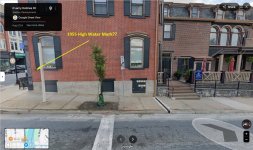
I don't know if it is still there, but there used to be a small plaque with the 1955 high water mark on the side of a building located at 101 Northampton Street (corner of Northampton & Larry Holmes Drive) in Easton on the PA side of the "Free Bridge" as it is known by folks in the area.

The building has been renovated and the old plaque is gone, but this MIGHT be a new one because that's where the old marker was:

101 Northampton St.jpg

It wasn't 1955, but like 25 or so years ago we had a crazy amount of rain two years in a row in the spring that they kept referring to as 100 year events. The Delaware was particularly hard hit.

After the first year of flooding, I happened to be driving along PA Routes 611 below below Riegelsville & 32 (River Road) and homes were washed away and more than a few were later raised a full story.

After the second year a lot of the saved homes were up for sale!!

After the storms in the second year, I had reason to stop at the Delaware Canal State Park Office which is 600 feet away up an inclined road (Lodi Hill Road) from the river bank and the river in that area is far below River Road. When I got to the park office there was standing water from the flooding...!!

Finally, same storms and years and I was on Route 209 above Bushkill, PA along the Delaware at the mouth of Tom's Creek. The adjacent road was washed out and there were corn stalks and husks stuck in three limbs at least 20 feet above the roadway. 😱

Crazy...
 
Last edited:
Speaking of the Delaware...

I don't know if it is still there, but there used to be a small plaque with the 1955 high water mark on the side of a building located at 101 Northampton Street (corner of Northampton & Larry Holmes Drive) in Easton on the PA side of the "Free Bridge" as it is known by folks in the area.

The building has been renovated and the old plaque is gone, but but this MIGHT be a new one because that's where the old marker was:

View attachment 1641243676

It wasn't 1955, but like 25 or so years ago we had a crazy amount of rain two years in a row in the spring that they kept referring to as 100 year events. The Delaware was particularly hard hit.

After the first year of flooding, I happened to be driving along PA Routes 611 below below Riegelsville & 32 (River Road) and homes were washed away and more than a few were later raised a full story.

After the second year a lot of the saved homes were up for sale!!

After the storms in the second year, I had reason to stop at the Delaware Canal State Park Office which is 600 feet away up an inclined road (Lodi Hill Road) from the river bank and the river in that area is far below River Road. When I got to the park office there was standing water from the flooding...!!

Finally, same storms and years and I was on Route 209 above Bushkill, PA along the Delaware at the mouth of Tom's Creek. The adjacent road was washed out and there were corn stalks and husks stuck in three limbs at least 20 feet above the roadway. 😱

Crazy...
They said that some rivers were flowing backwards in 1955. Bushkill or Brodhead I think.
 
They said that some rivers were flowing backwards in 1955. Bushkill or Brodhead I think.
Wasn't after the 1955 floods when the heavy equipment was brought in and decimated the Broadhead?
 
Wasn't after the 1955 floods when the heavy equipment was brought in and decimated the Broadhead?

Yes...

I read accounts of that flood and it was unbelievable. The dam on the Devil's Hole Creek burst sending a wall of water down the Brodhead. In addition to that, the Brodhead Watershed covers 294 miles so the flooding was horrific.

Bottom line, Hurricane Diane's waters ripped out 42 road bridges, 17 railroad bridges, and destroyed 20,000 homes.


For the Conestoga River at Lancaster the 100 year flood elevation is 26.1 ft.

The highest level recorded was 27.9 ft during Hurricane Agnes. (I saw the Conestoga then.)

The recent peak from this storm was 12.1 ft. So it peaked at an elevation less than half the 100 year flood elevation.
Getting way into the weeds here but maybe someone will find this interesting. Strictly from a statistical standpoint, in a few locations the rainfall of 5-6" over the short duration of a few hours may have qualified as 100-year event. For example if I was modeling the flood in some neighborhood and pulling this observed rainfall from gages I might say that study area experienced a 100-yr storm. But it was far too localized to generate the kind of flooding that something like Agnes (or Ida) produced.
 
2004,2011,2018 all wet years in Pennsylvania. Will 2025 finish as another year with above average precipitation ? If so it would be quite a coincidence in those years fall every 7 years.
In the DC area 2018 set a record for annual rainfall. I've been saying (mostly out of frustration ever since the storms started messing with my cicada fishing plans) that maybe this year is central PA's turn to set a record but haven't spent any time to see if it's on track for that extreme. Anybody know how it's comparing to average and to records?
 
Dang rain just chased me off the lawn mower with about 30 minutes of work to go... 😡

Another .25" to go with the 15.02" we've got since May 1...
 
"devastation on the delaware" is another interesting book on river floods. it was 1955
Most flyfishers probably like to be near streams and rivers, not just for the fishing, but also just for the beautiful views.

But never buy a house or cabin in the floodplain. A floodplain is a plain that floods.

The recent events in Texas are a reminder of that. A summer camp does not have to be in a floodplain. I went to two different summer church camps and neither had the cabins in a floodplain.

Public campgrounds also should never be in floodplains. The campgrounds at Sizerville State Park and Ole Bull State Park are in the floodplains. Do you know of other examples?

Those should be relocated to non-floodplain locations, both for safety reasons, and so the floodplains and riparian areas can be restored to benefit the streams. There are good numbers of wild trout directly above Ole Bull State Park, but low numbers below it. That State Park creates a severe impact on Kettle Creek.

The campgrounds at Hickory Run State Park, Ricketts Glen, and Cherry Springs and many others are in non-floodplain locations, and they are perfectly fine campgrounds. A campground does not have to be in a floodplain to be enjoyable and popular.

The location of campgrounds in the floodplains, like Sizerville and Ole Bull was a bad decision, that was probably made in the 1920s or 1930s. But we don't have to continue that, we should recognize the mistake and fix things.
 
Yea rain and high water are problematic, but lightning is a hard stop. Why do we have to have so many thunderstorms? They’re natural wonders, and I love them generally, but man they put a damper on my fishing plans. Ugh. Just screaming at the universe.
 
Yea rain and high water are problematic, but lightning is a hard stop. Why do we have to have so many thunderstorms? They’re natural wonders, and I love them generally, but man they put a damper on my fishing plans. Ugh. Just screaming at the universe.
Wait until you fond yourself i the middle of a lake with just trees, no horizon to see oncoming WX and one of those storms rolls over your circle of view.
 
Back
Top