Segloch, Lancaster County, 2/12/2013

JeffP

Well-known member
Joined
Nov 21, 2007
Messages
1,398
City
Lititz, Pa
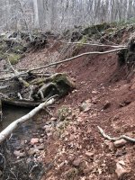
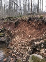
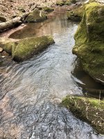
I got out for a couple hours on the game lands. Tons of silt, big-time erosion on steep hillsides, and nary a hit. I fished a black bugger. The water was a bit lower than I thought it would be. It was pretty depressing to see but about what I suspected. If anyone gets out there, put a report out. I think it's time to survey that creek. I'm tired about hearing about its class A status when I doubt it has much more than an occasional brown. I know we've talked about this one a lot so I'm not looking to stir up another long thread.
 
Your request/complaint would best be made to the PFBC Area 6 Fisheries Manager.
 
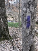
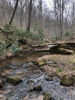
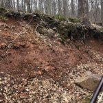
Here are some pics.
 

Attachments

  • IMG_2395.jpeg
    IMG_2395.jpeg
    429.9 KB · Views: 150
  • IMG_2393.jpeg
    IMG_2393.jpeg
    475.7 KB · Views: 158
  • IMG_2392.jpeg
    IMG_2392.jpeg
    449.4 KB · Views: 186
  • IMG_2391.jpeg
    IMG_2391.jpeg
    432.4 KB · Views: 183
  • IMG_2390.jpeg
    IMG_2390.jpeg
    161.9 KB · Views: 188
  • IMG_2388.jpeg
    IMG_2388.jpeg
    480.9 KB · Views: 163
  • IMG_2387.jpeg
    IMG_2387.jpeg
    643.4 KB · Views: 158
Yeah, there’s that red sand. (Not actually silt.) Pretty, but not good for habitat.

Image 2391 is the best big fish lair in the stream IMO. It was twice as deep following the 2011 floods as it is now. In 2013, I pulled a 13” Brown out from there. My best Segloch fish.
 
Those are some very high banks. Do you think that is due to legacy sediment deposited behind an old dam, or some other cause?

Are there high banks on both sides?
 
Honestly it doesn't look like legacy sediment. Yes on both sides but it doesnt dominate the stream. Most of those banks have been there for a while but definitely looks worse.
 
There’s no real problem. It’s not a very good stream habitat wise (most of the time), and it doesn’t have the habitat to carry that great of a population (again, most of the time).

I’m not sure when the survey was done that generated its Class A listing, but I wonder if it wasn’t during one of those periods after a pretty significant high water event temporarily moved the sand out of the stream bed, and improved the habitat for a while. Similar to the period of good fishing from roughly 2012-2015 following the 2011 floods that everyone is similarly reporting. I don’t have a doubt it would have surveyed Class A during that period. (I know the survey generating that listing is much older.)

Again there’s no problem. It’s just not that great of a wild Trout stream. Enjoy it for what it is, and where it is, or don’t.
 
The problem has been well-recognized for decades. Accepting reports that the stream may now harbor primarily brown trout, the problem for either species has been sedimentation. If on the SGL a dirt road still closely parallels the stream, the sedimentation problem is not going to be corrected anytime soon. Even if it were paved, the stormwater runoff , as it most likely does now, would still contribute to the bank erosion seen in the pic, which would then deposit sand in the creek. Likewise, in the past a trail on the slopes in the area was also badly eroded. It’s sandy soil and any disturbance on the slopes can result in sediment heading toward the creek. A fish population survey will do nothing to initiate correction of this stream’s problems and you can see these same sand-related problems associated with the sandy soil on other streams in the area that don’t have roads paralleling them. It’s a no win situation.

As for qualifying surveys, the first was probably the one in the late 1970’s, but after that the stream still remained Class A during some other surveys. I don’t recall that it ever dropped below Class A except during a survey conducted prior to opening day one year to specifically determine if the stream would do so at that time of the year. During the summer follow-up survey that year it was back to Class A again. I had once surveyed the stream when the boulders were nearly buried in sand, but I do not recall whether in that particular survey the biomass dropped below the Class A minimum. I came to the same conclusion as Swattie, however, that this was the way that the stream functions; that is, it gradually gets inundated with sand for a few years and then a major storm blows much of the sand out of the channel and then the process starts all over again. Welcome to the Furnace Hills. I would also add that while ST and BT will reproduce in sand, it is not an ideal substrate for trout reproduction and it can impair ( word chosen carefully) redd success.
 
Last edited:
We have been visiting and fishing this run since the 1970's. Things have changed drastically. Just looking at the immediate stream corridor from Laurel Run Road downstream is ignoring the big picture. Development on Cannon Hill and the headwaters have both depleted groundwater and increased runoff. I think a macro survey would be helpful also. When we surveyed it back in the 80's it had variety and abundance of bug life. Look at the West Branch above Laurel Road. That is the branch that carries the stream name. It is a trickle of pondwater and trampled horse pasture with NO vegetation and no discernible streambanks. But, but, the sand.............!
 
We have been visiting and fishing this run since the 1970's. Things have changed drastically. Just looking at the immediate stream corridor from Laurel Run Road downstream is ignoring the big picture. Development on Cannon Hill and the headwaters have both depleted groundwater and increased runoff. I think a macro survey would be helpful also. When we surveyed it back in the 80's it had variety and abundance of bug life. Look at the West Branch above Laurel Road. That is the branch that carries the stream name. It is a trickle of pondwater and trampled horse pasture with NO vegetation and no discernible streambanks. But, but, the sand.............!

All of the above may be true to some degree too. I don’t doubt it. But, I think the evidence suggests the sand limiting the habitat most of the time is the biggest limiting factor. This affects the macros too.

Again, I cite the very common sentiment that the stream was fishing very well from roughly 2012-2015 as evidence of this. We have half a dozen, or more, anglers reporting this same thing. The problems cited above…dewatering, runoff, horse pastures were all present before that last recent boom period of biomass in 2012-2015. Which immediately followed a scouring flood that greatly (albeit temporarily) improved the habitat.

I’ll be honest, prior to the 2011 floods I had fished it a few times, and never caught or saw a Trout. Caught a few Chubs IIRC in the bridge hole in the SGL. One day, after the floods, in 2012 I think, I only had a short window to fish, and I lived in South Lebanon Twp. at the time and could be on Segloch in 25 minutes or so from my house. So I went, not expecting much of course given my prior experience with it being sandy and having little habitat. It was like fishing a totally new stream. I loved it. The habitat was now great! I caught lots of small Trout, about a 50/50 mix of Brooks and Browns, and over the next several years the size increased, peaking in about 2015 or so. Then it started to go downhill. And IMO it’s back to where it was when I first fished it now, and I don’t have much of an interest to fish it anymore. Mike wasn’t kidding when he said that entire boulders, the size of beach balls, were completely covered by sand, and were now exposed. They’re completely buried again, you’d never know they were there.

It’s ok to have varying opinions on this, but my guess is after the next scouring flood, we’ll see another brief renaissance period for Segloch and the other Furnace Hills streams. We can test my “sand” hypothesis as being the primary limiting factor then.😉 Shearers, Furnace, Walnut, Kettle, Elders, and to a somewhat lesser degree Hammer, can be willing test subjects too.

 
Last edited:
If a “trampled horse pasture” on the west branch still exists today, it would perhaps be worthwhile discussing with the county conservation district.
 
I've only fished this stream once or twice and didn't do particularly well. The one morning I was there, it was really cold in the morning. I parked at the bottom SGL boundary. As I worked my way upstream, the water got cloudy. By the time I got up a place where the road crossed the stream, I found very recent evidence (hours old) of big trucks mudding it just off the road and through the creek.

Sediment has killed many of the streams that had flourishing populations of fish in ANF and I suspect it is a limiting factor on other streams I have fished as well.

The time period 2012-2015 - I wonder if there is something to that regionally being a peak in trout density in wild local streams. Streams I fished for the first time during that time period fished fantastic. And I've never remotely reached the numbers I caught then again, either in quantity or quality (length) of fish.
 
2014-2015 was a lot of fun. I think one day I caught 50 trout in a single outing. I thought it was the greatest stream ever. In the years to follow, I never caught more than half a dozen at a time. I’ve pretty much given up and fish entirely different counties now.

Along with the habitat and erosion issues, the stream tends to get pounded. I usually only fish it once or twice a year but I have always seen other people fishing when I have gone. It’s crazy for a small wild trout stream to get that much pressure. The fact of the matter is that it’s on the class A list and it’s extremely accessible. That makes for one bad combination.

Trout are not the only thing that suffer in that area. Deer and turkey are pretty much non-existent as well.
 
Google maps is a good way to see what the "west branch"/Segloch flows through. You can see the horse wallow as well as 3-4 ponds. There seems to be an abundance of mega house/compounds built in that area. Huge lawn areas with outbuildings usually with a long lane back into the forest. Not all of it is in the Segloch watershed but a fair number are. The area along the west branch is hard to even look at.

So, what does the conservation district actually do? Not sure why I need to alert them to the obvious. My guess is they only intervene when a farmer requests remediation or best-management practices. I bet they have little if any contact with small landowners "up in the woods". I have also seen a stream sprayed with herbicide on all its banks to keep it "neat". This one flows into Middle Creek. Like the Segloch example, within easy view of the road.

Hopback, those gamelands used to have flocks of Turkey and Grouse. It is sad to hear the forests have declined along with the streams. One thing I have noticed in these woods is increased numbers of invasive plant species. I think the timbering opens the land up to more opportunity for these invaders.
 
Back
Top