Lehigh Gorge Trib Question

This intrigued me. And then I went to the link and saw $200/night with a 2 night minimum in May. That's 2 new fly rods for me with some leftover for backing.

Unless there's 8 of us that want to chip in on a platform and split time over 2 days 🤣

I did go back and look through my stream plan tracks and I do think there's an overland track on public land that would get you to the mouth mostly on old logging roads.
I would be interested in any info you have regarding old logging roads. A friend did tell me that years ago a friend took him down an old rough road where they were able to park and then hike down to the creek. Unfortunately, his friend passed away and he has no idea where that old road is.
 
Before anyone goes and tries the rhodo/repel public land option from the east, I’d encourage you to view some ā€œleaf offā€ satellite maps of that area. Those aren’t pine trees you see, and if you can find a road grade that doesn’t peter out at the top of the mountain on those maps, you’ve got better eyes for it than me. I didn’t do that. Step one to using an old logging road is finding the old logging road. I never did.

The mouth is the public land path of least resistance IMO.
 
I would be interested in any info you have regarding old logging roads. A friend did tell me that years ago a friend took him down an old rough road where they were able to park and then hike down to the creek. Unfortunately, his friend passed away and he has no idea where that old road is.

Not sure, but that sounds like the old grade that is now gated and posted, and not on public land. See further up in the thread for more discussion.
 
I would be interested in any info you have regarding old logging roads. A friend did tell me that years ago a friend took him down an old rough road where they were able to park and then hike down to the creek. Unfortunately, his friend passed away and he has no idea where that old road is.
Boy, that sounds familure. šŸ˜‰ I'm envisioning a flotilla of kayaks on the Lehigh next season.
 
Last edited:
This intrigued me. And then I went to the link and saw $200/night with a 2 night minimum in May. That's 2 new fly rods for me with some leftover for backing.

Unless there's 8 of us that want to chip in on a platform and split time over 2 days 🤣

I did go back and look through my stream plan tracks and I do think there's an overland track on public land that would get you to the mouth mostly on old logging roads.

Totally agree. I’ve stayed at cheaper cabins with all the amenities. Depends how bad you want access to the creek
 
Totally agree. I’ve stayed at cheaper cabins with all the amenities. Depends how bad you want access to the creek
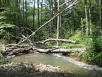
Even though those tents are in pretty close proximity to Bear Creek, it will still be pretty difficult hiking to get on the creek. Those rhododendrons are thick and tough to negotiate. Ideally, you'd want to hike downstream and fish it upstream, which would be quite the time consuming undertaking. That creek isn't easy, no matter how you go about it.
 
Spoke to a friend who has FFed Bear Creek a number of years ago. He told me that he believes his friend went down some old possibly logging road and they parked at a small clearing where people had camped. He told me there was a wash they followed down to the Lehigh, which brought them a couple hundred yards below the confluence with Bear.
 
IMO, I think the Bear Creek juice wouldn't be worth the squeeze for me. To hike in like I think would be required or to swim across the shark-infested Delaware River only to fish 3/4 of a mile on public land is a day I'd rather be on a different, longer stretch of stream that would expose me to a lot less risk to get to. That's why after plotting a track, I never pursued it.

Besides, based on the stream gradient, it's probably all invasives anyway šŸ˜‰ (you're welcome. Let the tangents begin!)

YMMV

Exception would be if one were to get permission from the owner(s) to hike down the logging road and fish back up past the State Park boundary.

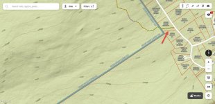
Question I have and how I'd be looking to find my way in on public land is here:

2025-12-31_18-42-08.jpg

This looks like an SGL easement but I can't determine if it is with certainty. This is just north of the logging trail I think we're all talking about here. If it is, that could be a way into the SGL from the top. I'd be looking at that as an option in.

BTW: I also think that logging road is more on public land than some maps actually show it to be.

 
IMO, I think the Bear Creek juice wouldn't be worth the squeeze for me. To hike in like I think would be required or to swim across the shark-infested Delaware River only to fish 3/4 of a mile on public land is a day I'd rather be on a different, longer stretch of stream that would expose me to a lot less risk to get to. That's why after plotting a track, I never pursued it.

Besides, based on the stream gradient, it's probably all invasives anyway šŸ˜‰ (you're welcome. Let the tangents begin!)

YMMV

Exception would be if one were to get permission from the owner(s) to hike down the logging road and fish back up past the State Park boundary.

Question I have and how I'd be looking to find my way in on public land is here:

View attachment 1641247716

This looks like an SGL easement but I can't determine if it is with certainty. This is just north of the logging trail I think we're all talking about here. If it is, that could be a way into the SGL from the top. I'd be looking at that as an option in.

BTW: I also think that logging road is more on public land than some maps actually show it to be.
Don't confuse this with a tangent. So, think or say what you want about Bear, but it was and may well still be, one of the best wild trout streams I've fished in the state. And, over the years I've fished some of the best the state has to offer.

Feel free to use DOD as an excuse not to fish it, but don't downplay it's potential as a really great stream, because it is. šŸ˜‰
 
Don't confuse this with a tangent. So, think or say what you want about Bear, but it was and may well still be, one of the best wild trout streams I've fished in the state. And, over the years I've fished some of the best the state has to offer.

Feel free to use DOD as an excuse not to fish it, but don't downplay it's potential as a really great stream, because it is. šŸ˜‰
YMMV. Got it.
 
IMO, I think the Bear Creek juice wouldn't be worth the squeeze for me. To hike in like I think would be required or to swim across the shark-infested Delaware River only to fish 3/4 of a mile on public land is a day I'd rather be on a different, longer stretch of stream that would expose me to a lot less risk to get to. That's why after plotting a track, I never pursued it.

Besides, based on the stream gradient, it's probably all invasives anyway šŸ˜‰ (you're welcome. Let the tangents begin!)

YMMV

Exception would be if one were to get permission from the owner(s) to hike down the logging road and fish back up past the State Park boundary.

Question I have and how I'd be looking to find my way in on public land is here:

View attachment 1641247716

This looks like an SGL easement but I can't determine if it is with certainty. This is just north of the logging trail I think we're all talking about here. If it is, that could be a way into the SGL from the top. I'd be looking at that as an option in.

BTW: I also think that logging road is more on public land than some maps actually show it to be.
What maps system are you using to see this?
 
What maps system are you using to see this?
Hi R42. The image is from OnX Back Country which is a really good resource and IMO, the best for scouting out property boundaries and quickly obtaining parcel ownership info: property owners and tax addresses, that sort of thing. But . . .

For plotting routes in advance and recording tracks on the stream, I use GaiaGPS for a hundred different reasons. I have paid subscriptions to many of them: OnX, AllTrails, Troutroutes, Garmin, GaiaGPS . . . but GaiaGPS is the best single app and the one I use for my pre-planning and tracking on the stream.
 
going to be up in the Gorge area this weekend, and wonder if any locals can report on water levels and temps in the tribs?
 
Back
Top