Bamboozle,
Thank you for this history. But it doesn't explain why that particular area has had increased wetness in the floodplains along the stream. There haven't been similar reports of increased wetness all along the Letort, or on similar limestone streams in the region like Falling Spring and Big Spring. The reports of increased wetness of the floodplains are for that particular area.
Does the increased wetness begin directly above the I81 bridge? That is what it looked like to me. People were talking about this and I saw it quite a few years ago. I think it was around the early to mid-1990s.
If the increased wetness does begin directly above the I81 bridge, that might indicate some change at or near the I81 bridge that altered the flow there, raising the water level upstream, and causing a grade control change, causing sediment to drop out above there.
A possibility would be some PennDot work under the bridge that raised the grade level. Another possibility would be the installed spawning area structures directly below the I81 bridge. I don't know when they were installed but I think they were there by at least the early to mid-1990s.
I'm not sure if those structures are still there or not. And if they are still there I'm not sure how much they affect the flow levels upstream. But the Letort is a very low gradient stream. And the I81 bridge is a choke point. The entire flow of the stream, including during flood stage, must go through that opening.
So, if the structures act as an impediment to flow there, that could raise water levels and cause sediment deposition upstream of there.
I'm not saying for sure that this is the explanation. It is just a possibility to check out.
The increased wetness and flooding I'm referring to, is from the footpath leading to the stream from Vince's Meadow up to and beyond what the regulars call the "Little S," a distance of about 50 yards.
BEFORE the heavy rain events of 2004/2005 the bank there was basically dry/occasionally damp and it was VERY easy to fish/walk/kneel/crawl upstream to target rising fish or just look for risers before going back to the car to suit-up.
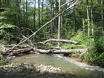
It started out muddy and now looks like this or is completely under water ALL the time (photo from 2006):
Directly upstream of the Little S, it used to be possible to walk along a dry bank and observe, fish or just walk through to get to the next meadow. Now that bank is basically gone.
If you want to walk upstream without sloshing through water at the edge of the stream and scaring every fish within 100 yards, you have step off the small footbridge over the old millrace on the trail from Vince's Meadow, hop INTO the millrace and slosh upstream and pop out where you want to fish.
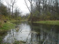
That's what my buddy (who is barely visible) had to do to get to the spot he is fishing in the photo below:
Above there to Otto's the banks are dry/firm and pretty much the same the same size as I remember them from many years ago.
BELOW the end of the trail from Vince's Meadow through what the regulars refer to as the "Barnyard," those banks are also high & dry and look the same. Here it is in 2005:
As far as the I-81 bridge; before my time fishing the Letort the stream switched back and forth in that area. When they built the highway, they straightened out the creek so if ANYTHING it is less of a choke point than it was before.
In regards to the area directly above, walking through that area was always tricky and accomplished by virtue of stepping stones put in the creek to get you to the next dry spot.
Below is looking upstream from just below the overpass in the 1980's. There were stepping stones and some wire mesh stuff in the water between the spot where my then girlfriend (now wife) is standing to the rocks by the overpass support and other places in the water further upstream:
FWIW - We walked up to this spot from behind Charlie Fox's house at the end of Foxcroft Drive. If you knew my wife, you would know there was NO way she would have done the walk up TO this point if the banks were muddy or wet.
😉
Below are two photos of the area just above the I-81 overpass on the same day. As you can see, getting up to the dry bank by the spring house behind the old Laudenslager farmhouse always involved getting wet, even if you parked in the small pull-off just south of the I-81 overpass and walked in from there:
In summary, the only dramatic changes I've seen are in the area from the end of the trail from Vince's Meadow to approximately 50 yards upstream. Why that is the case I don't know, I just KNOW it wasn't that way before 2004.
I was never a big "picture snatcher" and I didn't get a digital camera until 2004 so I don't have any circa 2000 - 2003 photos of the Letort to prove my point. I also no longer carry a camera so I don't have any current photos, but I was there last year.
FWIW - The somewhat permanent spawning areas created at the end of Foxcrest Drive behind Charlie Fox's house go back to at least the 1980's and there are seasonal spawning areas set up at Vince's Meadow since CVTU purchased the property in the 1990's?
I'd find it hard to believe it took those small spawning areas 45 years to wreak havoc with the Letort....
Today there is definitely less room along the bank in several spots giving the impression of the stream is widening. However, I'll chalk that up to trail & paths becoming overgrown to the point where they are impassible forcing an angler to walk at the water's edge to move upstream or fences being moved which is the case just below the upper RR trestle at Otto's.
This wasn't the case when I regularly fished from I-81 or below all the way up to Bonnybrook Road on a daily basis, However, the stream width today looks pretty much the same to me as it has my whole life.
Beats me...