using maps to tell rhodo from hemlock in tiny nepa brookie streams?

k-bob

Well-known member
Joined
Jul 29, 2009
Messages
2,397
2 recent posts:

"Will this virtual program teach me how to identify hemlocks on aerial maps 🙂?" : jeffroey.
"When studying sat maps it is often very difficult to tell the difference between a rhodo thicket and grove of hemlocks, which are wonderful to fish through IMO." swattie.

I agree w issue, and here's an idea but no magic bullet... tiny nepa streams are sometimes lined with some hemlocks when surrounding area is rhodo. can be tough to guess if there is hemlock from even good leaf-off satellite map. hemlocks (thank god) are taller. try this tree-height map:


as example, put "oberson run" as location in the tree-height map. see oberson area in "map" and "satellite" base images. toggle tree height layers on and off. zoom around and to me there's little suggestion of hemlock breaks in rhodo hell. ('cept maybe where oberson joins quakake)

now try "West Diaz Avenue, Nesquehoning, PA, USA" as location (just south of oberson)... that pair of tiny UNT streams above it to northwest may be too small to fish, but the western one for example looks better for some hemlocks along the trib.
 
Last edited:
Wow what a cool map. I think it will take some exploring with this to see if the some known laurel areas show up at what layer of the map for height. I know of one, Laurel Run (go figure) in Union County. I need to do some playing on this to find the right < height for laurel.

I had a class for my cartography program at college called Aerial and Satellite Interpretation. We used old black and white Army maps some early floppy disk software on an Apple IIe. We have come a long way.
 
2 recent posts:

"Will this virtual program teach me how to identify hemlocks on aerial maps 🙂?" : jeffroey.
"When studying sat maps it is often very difficult to tell the difference between a rhodo thicket and grove of hemlocks, which are wonderful to fish through IMO." swattie.

I agree w issue, and here's an idea but no magic bullet... tiny nepa streams are sometimes lined with some hemlocks when surrounding area is rhodo. can be tough to guess if there is hemlock from even good leaf-off satellite map. hemlocks (thank god) are taller. try this tree-height map:


as example, put "oberson run" as location in the tree-height map. see oberson area in "map" and "satellite" base images. toggle tree height layers on and off. zoom around and to me there's little suggestion of hemlock breaks in rhodo hell. ('cept maybe where oberson joins quakake)

now try "West Diaz Avenue, Nesquehoning, PA, USA" as location (just south of oberson)... that pair of tiny UNT streams above it to northwest may be too small to fish, but the western one for example looks better for some hemlocks along the trib.
Thx for sharing this Bob. Going to do some experimenting w the streams I already know the cover for - good and bad - and see how this translates.
 
So I looked at a place I know is a rhododendron hell and it tells me the canopy height is 15. Is that 15 meters and if so I don't recall ever seeing rhododendron that tall...
 
So I looked at a place I know is a rhododendron hell and it tells me the canopy height is 15. Is that 15 meters and if so I don't recall ever seeing rhododendron that tall...
I've fished many streams that had large, thick areas of rhody, and have never seen it taller than 15 feet. I'm sure that 15 means feet.

It's a special treat when you can catch the rhodys, and mountain laural for that matter, in full bloom while on the stream. I've experienced this on Stony on a few occasions. Timing is everything.
 
I have only used this to try to guess where a rhodo area may also have some hemlocks (and of course be better to fish in). as noted "hemlock in rhodo" can be tough to discern on even good leaf-off map. some streams have hemlocks along their course w/o having them in surrounding terrain.

on a relative basis -- lighter suggests taller -- I like to use the tree height map versus just a leaf-off map. carbon county rhodo and I go way back, so I can look at images and recall places.

of course there may be a large height difference between surrounding rhodo and a hemlock tree. so in areas widely covered in rhodo, contrast may be sharper. in places where surrounding trees are more similar in height to hemlock trees, and more mixed, the map may not help in suggesting "hemlock on stream" (isnt that a town in england?)

also fun to check the terrain box under map... in some places the taller trees may be on ravine sides and not over the tribs...
 
Last edited:
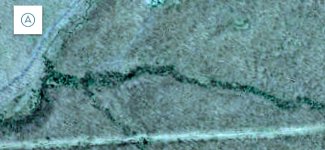
In non rhodo areas, tribs w bankside hemlocks are sometimes easy to see on a just a leaf-off map. Image of trib w serious hemlock lining, Luzerne county,,, (approx 41.199352, -75.871296... doesn't fish well sadly due to high acidity)

tree height may not help spot hemlocks in areas where, as in the imaged area, the trees around the hemlocks are of a similar height to hemlocks... but where it's relative to rhodo, tree height may add value versus just having leaf-off map...
 

Attachments

  • 20260411_145519.jpg
    20260411_145519.jpg
    93.7 KB · Views: 22
Last edited:
You might be able to correlate rhododendron with either soils or bedrock geology, or both.

I'm not going to try to do that, but if someone else does, I'd be interested in what they find.
 
I have read that rhodo can thrive after disruption such as historical logging. Having fished in a lot of it, I didn't like it even before I read that!
 
Last edited:
Rhododendron is a native plant, so it was present before the logging days. It would be interesting to know how much rhododendron there was back in the pre-disturbance era compared to now. But I don't know how you would determine that.
 
"It would be interesting to know how much rhododendron there was back in the pre-disturbance era compared to now."

more rhodo now? (article below) I know little about forestry, but large mono-species rhodo vegetation areas such as north of drakes creek carbon county = not optimal & probably not there historically? whether rhodo is native or not?

still, it is what it is, and & expanses of rhodo may make some (much taller) hemlocks lining a stream easier to see w/ tree height map


"Rhododendron has replaced American chestnut as the ecological dominant in many cove forests of the southern Appalachians (Vandermast and Van Lear 2001). Following the chestnut blight, logging, and fire exclusion early in the last century, rhododendron has expanded far upslope and now tends to direct forest succession and development by affecting establishment and growth of advance regeneration and seedlings. With the exception of Eastern hemlock, no other woody species appeared to have the ability to attain overstory status on these study sites, although Phillips and Murdy (1985) and Clinton and Vose (1998) noted that red maple could regenerate and become established on some sites dominated by rhododendron. Herbaceous species richness declined markedly with increases in density of rhododendron thickets and after decades of rhododendron dominance may now be lost from certain sites in these riparian/cove forests."
 
Last edited:
drakes creek is good example of brookie fishing use of tree height map in a rhodo expanse area. if you just put "drakes creek" in the tree height map and know that the area north of of drakes creek road & school house road became public. ... you might think that just north of the intersection of drakes creek road & school house roads there are a few taller trees over the stream. some hemlocks in the rhodo? much better to fish with some hemlocks & not solid rhodo hell o'er the stream...

article on rhodo thickets in previous posts suggests that taller trees in rhodo may well be hemlock: "With the exception of Eastern hemlock, no other woody species appeared to have the ability to attain overstory status on these study sites, although Phillips and Murdy (1985) and Clinton and Vose (1998) noted that red maple could regenerate and become established on some sites dominated by rhododendron."

....
but if you use the map's slider transparency control under "Canopy height v2" to see through the tree height colors, and also check the "terrain" tab under map to show width of ravine and stream location in it.... that little stand of likely hemlock appears possibly on slope down to stream versus over stream. stream itself looks like a solid rhodo hell.

this was my experience fishing there... can't say I recommend it.
 
Last edited:
article on rhodo thickets in previous posts suggests that taller trees in rhodo may well be hemlock: "With the exception of Eastern hemlock, no other woody species appeared to have the ability to attain overstory status on these study sites, although Phillips and Murdy (1985) and Clinton and Vose (1998) noted that red maple could regenerate and become established on some sites dominated by rhododendron."
Rhododendron and hemlock are often found together.

But I think I recall seeing rhododendron growing under hardwood trees also.
 
There are many historical accounts of pioneers and settlers in the Appalachians trying to navigate rhododendron thickets. They often called them “laurel hells”.
 
So are we all saying this software can't tell the difference between hemlock & rhododendron because in my limited testing...

It can't...
 
There are many historical accounts of pioneers and settlers in the Appalachians trying to navigate rhododendron thickets. They often called them “laurel hells”.
That's an appropiate name for it. You get turned around in that stuff and you're in for a rough time. It's usually tall enough that you can't decipher the geography around you to get your bearings. And, that stuff is tough as nails!
 
You mean AI can't help us there? 😆

It will once we all go out and make our discoveries the old fashioned way by driving out to a location and reporting our data to whatever AI repositories are out there for such things...

In the meantime, I'm sticking to the old fashioned way for the foreseeable future...
 
Back
Top