Savage River/N. Branch Potomac, Garrett Co., MD, 02/17/2010

3wt7X

Active member
Joined
Nov 19, 2008
Messages
704
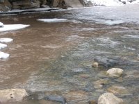
A buddy and I made the trip out to the Savage river today to see the damage. It was about 35 degrees throughout the day with snow flurries. The Savage river is a mess at this point. The flows were approximately 70 CFS thoughout the day and there was about an inch visibility in the water. The discouraging part was the sheer volume of sediment on the riverbed. I observed 2-3 foot of packed mud/silt in areas that were formerly boulder strewn. On a positive note, we did not observe any dead fish, in fact, we did not observe any fish at all at the Savage. I am going to remain optimistic and say that they survived, but that stream is going to need some serious water to restore the old stream bed and wash the silt down.

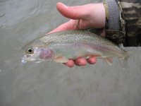
After our depressing trip to the Savage, we drove down to the N. Branch of the Potomac below the confluence of the Savage river. The water was in better condition on the N. Branch, but it was still very cloudy and cold. We slow swung streamers in the area of Westernport and I came up with two decent rainbows. A very slow presentation was needed and the fish seemed to hit as the streamer was just lifting off the bottom.

Picture discription:
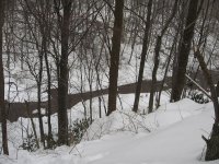
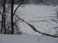
1)The area where Savage river lake used to be.
2)The Lower Savage river Gourge
3)The confluence of the Savage and the N. Branch
4-5) A couple of nice N. Branch Rainbows.
 

Attachments

  • SL.jpg
    SL.jpg
    77.1 KB · Views: 14
  • SL1.jpg
    SL1.jpg
    112.7 KB · Views: 1
  • SL2.jpg
    SL2.jpg
    86 KB · Views: 15
  • SL3.jpg
    SL3.jpg
    46.6 KB · Views: 15
  • SL4.jpg
    SL4.jpg
    86.2 KB · Views: 14
Did you really not stop and take pictures at the couple bridges or did those pics not come out? The walking bridge pool would have given a good idea of the extent of siltation as well as the area of the PhD hole.
 
Jack,
You really could not see the siltation from the bank. It only became appearent when you attempted to wade and felt you foot sink into about 6 inches of mud. Here are a couple more pics of the water clarity, I guess I could have grabbed a hand full of silt and taken a picture of it for you, but I figured if you wanted to see something like that you could always image search "mud" on Google.
 

Attachments

  • savage%20river%202010%20feb%20002[2].JPG
    savage%20river%202010%20feb%20002[2].JPG
    54.3 KB · Views: 9
  • savage%20river%202010%20feb%20008[2].JPG
    savage%20river%202010%20feb%20008[2].JPG
    46.4 KB · Views: 11
  • savage%20river%202010%20feb%20019[1].JPG
    savage%20river%202010%20feb%20019[1].JPG
    40.7 KB · Views: 11
Thanks for the heads up Josh. It's good that we finally got a forum regular out there to get "eyes on" and verify or refute the rumors. It's iteresting how iced up the Savage is. I suspect that, under normal conditions with water withdrawels, the creek would be less iced in winter(?) In any event, let's hope for the best. As other have suggested in other threads, these creeks are resilient and often bounce back pretty quick. With the amount of silting you describe, I'm a bit worried about macros but I'd suspect that the silting is heaviest along the banks whereas the main channel may be better off, esp if flow rates remain good with snowmelt. As you know, much of the shoreline of that section of stream is irregular with a lot of large boulders and eddies rather than a gradual slope and this may help "trap" some of the silt in certain areas which may diffuse some of the impact.
Thanks again. And nice job on the NB 'bows.
 
Actually the way I see it, things are looking really good for the Savage. This has been one of the snowiest winters on record and once the gate is hopefully complete next month and they begin to fill the reservoir again, there may be actually enough water supply to have a release or two instead of just maintaining the required outflow. Lets just hope there is no warm up and spring doesn't show up too soon.

The sediment was expected. Last September I remember finding an environmental assessment (EA) for the gate work and the sediment storage behind the dam was discussed in detail.

Here is a link the summarizes the plan.
http://senecavalleytu.org/savage-river-dam-repair-info/

Recent update:
http://www.tidalfish.com/forums/showthread.php/280978-Maryland-DNR-Advises-Anglers-of-Poor-Savage-River-Conditions

I too have been following this closely since I see this project as being one of many projects where dam retrofitting will need to occur on our tailwaters. Thanks for bringing back some pics 3wt, with a baby on the way next month for me, haven't had much time to get out there at all.

Thanks,
Pat
 
3wt7X,
Thanks so much for the report and great info.

I have often marveled over that resource, but I fear that the worst has occurred. There were fears expressed before about the effect of flooding and the traumatic movement of fish and the well documented effects of massive siltation (many western tailwaters have never come back from that). Yes, it may rebound somewhat with stocking as a fishery of sorts - but what abeaut before - nevermore...
Very sad...

But thanks for the interest and concern to get a report our way...
 
Hopefully not turning this stream report section into a "conservation" thread but 🙂

NativeBrownie,

I believe that the trout will return if the macros return. Maybe not immediately, say this growing season, but they will come back.

The reasons why I think is the case is because the work is being done in a very short period of time, over the winter months vs. a yearlong or longer event (growing season impacted-time frame). The sediment covering the bottom is probably clean sediment, not filled with what you would find behind the Conowingo dam, where you have urban/ag development upstream, which is probably contaminated and could cause a kill. No fish kills have been documented other than a couple of warm water species, which were probably in the reservoir anyways. I am sure the trout would have moved on once the first signs of silt were headed downstream and there was relatively close refuge in the Potomac (probably the most important aspect when compared to western tailwater scenarios).

The Savage River channel is a type of channel which manages fines (clays/silts) very well. From the visits I had there of the years, I remember certain pools/pocketwater where I caught fish during previous years, that weren’t there the following year because the boulders moved or the pockets got filled in. Since the channel has a braided pattern of flow because of the bed material, there is no confining channel where you would have excessive sediment build up of typical stream features like a point bar or the tail of a pool. If there is sediment build up in the channel, most likely it won’t last and will be placed on the floodplain, which there isn’t much of, or it is sent downstream, which is my worry. Also I believe since the channel will manage removing most of the sediment, what’s left behind will be great for macros that love the sediment (green drakes, tricos etc.) and will provide “abundant” material for new spawning beds.

Hopefully, for the sake of an incredible stream, some of what I spoke about will become the truth, at least that is my hope!
 
When I was in Idaho freelancing for the Forest Service I was sent to cover a 99 year old dam on the middle fork of the Boise River that was about to go in the town of Atlanta. When it did, nearly 100 years of silt and heavy metals from mining washed down the Middle fork. Upstream looked way worse then your pics and downstream looked worse. In the end there was a consumption advisory put on the fish that survived the incident and it was lifted after only two years. The fish came back eh river came back and the dam was replaced. Don't go slitting your wrists just yet.

http://news.google.com/newspapers?nid=1314&dat=19910528&id=0EcSAAAAIBAJ&sjid=vPADAAAAIBAJ&pg=3252,4899804

http://news.google.com/newspapers?nid=1298&dat=19910530&id=qNQQAAAAIBAJ&sjid=wIsDAAAAIBAJ&pg=2597,319942

If you look (I gotta go) you can probably find article on the recovery. And I guess the dam was 86 not 99 but that's what I remembered.
 
Skeeter,
Well presented and nicely thought out. Makes for optimism - may eventually return and your point about the Potomac as a healthy haven is a good one. Yet, while man made, the Savage was "pristine" (relatively) -that is hard to lose in this day and age. I do fear that we are talking about a great, great deal of sediment - no expert here, two of the greatest threats to a fine trout river are flooding and massive sediment... From my friends on the Henrys Fork - the river has never been the same since the one heavy shot of siltation of the past... I am sure that you are right - at some point - there will be a return to a fine trout river. But there is a great deal to grasp here that is lost...
 
I would agree the river section from the dam to the Potomac will never be the same, but I think conclusions of doom are premature. There will be more areas of silty deposits for years to come, but there will also be new pools and flats, etc, as that sedimentation is marginalized outside of the main flow. If the main flow paths are completely silted after the event subsides, there is something to worry about. Otherwise, I think the river will be fine. That was why I was curious if you got pictures from the bridges.
 
Back
Top