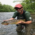
Letort Spring Run, Cumberland Co., 04/01/2017

3wt7X

Active member
Joined
Nov 19, 2008
Messages
704
Time Fished: 0645 am- 1030 am

Weather:
It was overcast with temps in the mid to upper 40s and very little wind this morning. Nice weather for opening day of trout in this area of PA.

Water:
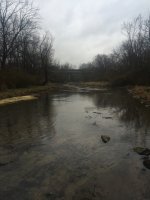
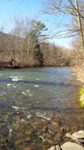
It was low, the lowest that I have ever seen the Letort, on the tail end of a pretty wet week. The water was crystal clear near bonnybrook road and a little chalky down near the monuments. I observed some odd conditions. The stretch near the monuments was nearly empty of any water cress, and it is almost completely silt. I looked bad to me, but I don't fish it enough to know if this is typical for this time of year. The fish were there sparsely and oriented to any cover they could find, which was very little. The stretch up at Bonny Brook looked normal and beautiful.

Hatches:
I wasn't there for the buggy part of the day, but as I left the midges were getting going. I did not see any olives, but it was early.

Tactics:
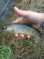
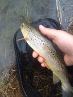
Slow stalking with light weighted streamers. I've had enough practice at it, since my local limestoner has been so low as well this year. Fish were very aggressive right at sun up, then the short strikes started. Landed 4 beautiful Letort Browns, and enjoyed a short get away.
 

Attachments

  • LT1.jpg
    LT1.jpg
    136.2 KB · Views: 22
  • LT2.jpg
    LT2.jpg
    145.2 KB · Views: 25
  • LT3.jpg
    LT3.jpg
    81.3 KB · Views: 18
Congratulations! Four on one of the toughest trout waters in PA or anywhere else is very impressive.
 
I'd be interested to hear what the Letort regulars have to say about the watercress dying back.

Normal winter thing, or something else?

Here in Centre County, I gather watercress to eat. And in the winter time it dies back.

Then grows again when things start warming up.


I'm not sure... but fluctuation of aquatic vegetation is not unusual in the CV streams. Some years there can seem to be a good bit less of cress, elodea, and other vegetation. Some of the vegetation includes invasive grasses. Sometimes these creeks can appear quite barren in late winter. Also, flow rates have been unseasonably low on the CV streams as well the last few months and this may have played a role as well


Some of the Letort regulars pull vegetation out of certain spots as well. This sounds to me like a natural fluctuation however. Recent years have seen very heavy weed growth in the Letort which has caused problems and a natural abatement might not be a bad thing.
 
The stretch shown in the photo looks very barren.

The physical habitat doesn't look good. What's going wrong there?
 
That bottom photo was facing I-81 towards Letort Park from the Heritage Meadows. For those unfamiliar, that is pretty high up on the stream, upstream from Carslile. That whole stretch looked barren like that. I trust Dave's observations are correct and it's just maybe it's an off year for the vegetation. Then again, if you go just a little further up to Bonny Brook, it looks as lush and green as ever. I just wanted to spread the word a bit on what I saw.
 
Yeah, it's a seasonal fluctuation, enhanced by the low water conditions. Water levels drop, and a lot of the weedbeds get exposed and then die off, you can see it on the left hand side of that bottom pic. You can also see how low the creek is. Often you'll see the weeds die off on a stretch here or there, but with water levels being so low for the last 6 months it's really taken a widespread hit this year...
 
Ottos meadow...... within the past year or two that particular section has definitely changed imo. The flow used to be heavier on the right side looking down. And was slightly deeper. Since has silted in and changed to the left side but, looking at it there it might have silted that in as well. Was a good stretch there. Looks barren.

 
Yes, it looks very silted in. Is there something downstream, maybe at or near the bridge, that is acting as a grade control? That is backing things up, slowing the water in this stretch, causing sediment to drop out?

Also, the photo shows short grass along the banks in much of that stretch. Is that happening on its own, or is someone mowing?

 
No, there's no mowing going on, the grass is short/matted because it's the end of winter. The Letort has always had the silt in it, there's not much of a gradient anywhere along it's course until you get below town.
 
No, nothing down by the bridge any different than before in terms of man made structure. There used to be a deep week patch and run about 50 yards below where I was standing. There also was a deep channel on river right near that shrub that extends down to the bank. Now the center is a large pile of silt extending out of the water, with little depth on the sides. It did not appear that grass was mowed, just short. I will note that in many areas, the silt and mud extended from the waterline about 12" to the grass. I've never seen that on the Letort.
 
Now the center is a large pile of silt extending out of the water, with little depth on the sides. It did not appear that grass was mowed, just short. I will note that in many areas, the silt and mud extended from the waterline about 12" to the grass. I've never seen that on the Letort.

Yeah, the water is super low right now, scary low, that's what your seeing...same thing is happening over on Big Spring. Historic low flows according to the USGS gage and silt bars being exposed there also.
 
Was at the Letort this afternoon. Lowest I've ever seen it myself. Normally I'm wearing hip-boots, like I did today, and can only cross in certain sections. Today, I was easily able to wade from one side of the stream to the other in stretches that would normally fill my boots up with one step off the bank. . (Got photos but unable to load pics)

The worst section looked to be just below the meadow where the lady statue is- it was "around" ankle deep in some spots - barren muddy banks exentending quite a few feet down to the water line .
Also noticed the usual swampy areas that parallels the trail was dry.
Was hoping that rain would of helped a bit, but I guess not..
 
this is very interesting to hear. I made my first visit to the letort in the monuments section on friday, in the cold rain, and was surprised how shallow, silted in, and free of vegetation the stream was. Didn't see any fish. It was hard to reconcile those conditions with the legend.

 
I fished the letort on 4/1 as well from 9 to 330. Did well on red zebra midges size 20 and a holy grail size 16. Also got one on size 18 bwo. Great report on my favorite water!
 
I was curious about the numbers, so I just did some poking around on the NWS site. According to the annual precip graphic, the rain that fuels our valley springs was around 8" below normal last year, then add in a slow start to the year this year and it could be a while until we see water levels really rebound.


2016 Annual precip map, departure from normal
 
mikesl wrote:
this is very interesting to hear. I made my first visit to the letort in the monuments section on friday, in the cold rain, and was surprised how shallow, silted in, and free of vegetation the stream was. Didn't see any fish. It was hard to reconcile those conditions with the legend.

This is a common first time experience for folks at Letort and explains partly why so many anglers do not return.

The fish are in there, but it is a mucky stream and there can be long periods between surface activity.
 
I agree with Tomitrout that this is a function of the very low water levels this year.

Keep in mind, that the Letort looks and feels very different over the seasons. In summer, the very dense weed growth actually displaces water up into meadows and creates the illusion of deeper water. Moreover, the dense weeds create current channels in between them that force the flow at a faster speed that flushes out these weed channels and also make it appear deeper.

In winter, with weed die off, the stream seems much lower, slower, and shallower. It really is lower and slower this year, but some of this is a seasonal illusion.
 
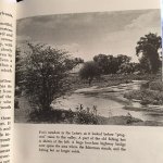
A view of how Fox's Meadow appeared about 1970.
 

Attachments

  • Letort2crop.jpg
    Letort2crop.jpg
    48.4 KB · Views: 16
actually the above photo was likely taken by Marinaro in the early 1950's prior to the construction of I-81. The pic is copied from "A Modern Dry Fly Code" second printing, which I recall was 1970.
 
Back
Top