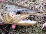
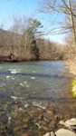
Fishing Creek (Lancaster County), 6/21/2014

Given the spread of age classes and the total number of streams, its much more than just rainfall/snowfall. I'd guess its a wide variety of factors:

1) Reduced agricultural runoff. Not just from buffer zones, but in general just better agricultural practices, better education, better regulation. You can see the long-term trends across the basin at the USGS site for the Chesapeake Bay: http://cbrim.er.usgs.gov/maps/index.html

2) Decreased atmospheric deposition of pollutants and specifically acid rain. The 1990 Clean Air Act amendments in particular led to a fairly steep decline in the following decade. In PA average rainfall pH values in many locations was about 4.5 in the early and mid-1990's but by 2010 it was typically 5.5-6.5. That's a HUGE difference for breeding success for trout, especially in freestone streams with low buffering capacity.

3) Buffer zones on headwaters. There's a LOT more of this than there used to be. I left here 20 years ago and it was a rare sight back then. Now many of the fields I go to have fences up to keep the cattle out of the water and buffer zones with small trees. A ton more could be done here, but its amazing how much has already been done. This plays a key role not only in reducing non-point-source pollution but also in keeping water temperatures cooler for longer periods of time.

4) Small stream dam removal. This is another long-term trend where public opinion has helped shift things in favor of the coldwater migratory fishes. More and more of the small stream dams are being torn down as time passes by.

Jeff
 
Around my house I still don't see a lot of signs of better agricultural practices. Still plenty of cows in the streams, fields plowed right to waters edge, barnyard runoff into streams.
 
McSneek wrote:
Around my house I still don't see a lot of signs of better agricultural practices. Still plenty of cows in the streams, fields plowed right to waters edge, barnyard runoff into streams.

Yeah, I know its still bad. However, having grown up here and then coming back after 20 years away I can tell you its much, much better than it was. Its one of those things that's no doubt harder to see without having been away for a while.

I like to birdwatch and in the spring and fall I have always looked for shorebirds and snipe in the wet meadows and stream edges in pastures. This past year as I went around to many of the old spots I used to visit I was pleased to see a significant number of them now fenced off and growing with thick vegetation and/or trees--even on some Amish farms.

As projects like the ones TU has done on the Donegal and Conowingo have shown, even a little bit of increased buffer and shade can make a real impact. We have a long way to go before most of our streams can be returned to better health, but we're making progress.

Jeff
 
Land use changes. Headwater streams going from active farming to buffered/fenced corridors.

ATW attrition - Far fewer small streams stocked and the ones that are still stocked are stocked with fewer trout.

Hatchery reductions. Elimination of Big Springs 800,000+ trout into the commonwealth. NPDES permit biomass reductions at other facilities.

Reduction in angler numbers.

Reduction in Creel limits.

Increase in C&R mentality of remaining anglers.


I also think there is merit to the fact that there is an incredible fall off in spin/bait fishing one month into the season. These guys get there stringers in early spring and then disappear. That leaves fishing to the more conservation minded anglers that permeate this web site. Here in DELCO CHESCO by and large the bait guys head out to the shore one month or so after opening day
 
Maurice wrote:
Land use changes. Headwater streams going from active farming to buffered/fenced corridors.

I think that is probably the main explanation.

Because not only have wild trout populations expanded, but Mike has reported that on several of these streams, the minnow populations used to indicate warmwater streams, and they have shifted to minnows more typical of coldwater streams.

So, the water temperatures have shifted towards the cooler side. That could be explained by better riparian vegetation. The vegetation creates shade. And I've seen some streams narrow considerably, i.e. to about half their former widths, after riparian fencing. Both of these result in cooler water temps.

"Cool" stuff!!
 
Clearly, it is a result of and a harbinger of global cooling.

I really don't think you can attribute it to any one thing. And an upward swing over five years of trout populations could just as easily be wiped out by a major one year downward swing. Its dangerous to ascribe long-term trends to short-term wiggles..
 
salmonoid wrote:
Clearly, it is a result of and a harbinger of global cooling.

I really don't think you can attribute it to any one thing. And an upward swing over five years of trout populations could just as easily be wiped out by a major one year downward swing. Its dangerous to ascribe long-term trends to short-term wiggles..

I would agree, and its no doubt a number of factors. That said, the fact that its happening all over the state and on a variety of different streams implies its more than just a "short-term wiggle" and more of a medium to longer-term trend.

Well, at least I hope so. I would bet that the data is out there to do analysis on this on a larger scale. It would be an interesting project for a student in wildlife or conservation biology to undertake.

Jeff
 
Alnitak wrote:
That said, the fact that its happening all over the state and on a variety of different streams implies its more than just a "short-term wiggle" and more of a medium to longer-term trend.

It would be an interesting project for a student in wildlife or conservation biology to undertake.
Jeff

Agree with both above. It would be a complex study and would have to have good data from "before" to compare with today. Nevertheless, I too am convinced that wild trout in my neck of the woods are doing better in more areas (not all) than I can remember in my years of fishing central PA.
 
For the record on Fishing Creek, I add the following.

There are 2 parcels comprising the Fishing Creek Preserve; the lower parcel where the OP fished, and the upper parcel along Scalpy Hollow Rd. The 2 parcels are separated by about 2 miles of Fishing Creek.

On July 4, 2014 I visited the lower parcel in the vicinity of the 3 concrete fords mentioned by the OP. Water was low and somewhat discolored from thunderstorms the previous day. Water temp at 5pm was 69F. No trout were observed or caught, but the dace were active.

On July 9, 2014 I visited this reach of stream again with the same result, though the water was very clear. Water temp at 8 am was 65F. At 1130 am the wtr temp was 66F. No trout were observed in this reach.

At noon on July 9 I arrived at the upper parcel along Scalpy Hollow Rd. Wtr temp at noon was 66F, and at 4pm it was 68F. A wooded tributary flowing into Fishing Creek near the Scalpy Hollow parking lot was 64F at 4pm. Small wild browns were observed and caught in this reach of FCr.

 
I spend some time in southern York, mother in law lives there. Over the years there has been a noticable shift - in the area she lives (Fawn Grove) toward no-till farming. In theory this should reduce runnoff and siltation. I think the Amish still plow there.
 
There is a major tributary about one quarter mile upstream of Furniss Road which is pastured and lacks any riparian vegetative cover. This is likely a source of sediment and thermal pollution to Fishing Creek in the lower preserve area.

But I suspect the major factor limiting the available habitat within the lower preserve reach ( the area mentioned by the OP) is the location of Fishing Creek Road, which dominates the gorge and has likely eliminated any floodplain that might have existed within the gorge at one time.

There are also remnants of old stone channel deflectors within the stream at both preserve parcels. Does anyone know the history behind these structures? Unfortunately they have done little to improve stream habitat.
 
Tups wrote:

But I suspect the major factor limiting the available habitat within the lower preserve reach ( the area mentioned by the OP) is the location of Fishing Creek Road, which dominates the gorge and has likely eliminated any floodplain that might have existed within the gorge at one time.

I wonder if the Conservancy would consider "road ripping" the sections of the road that are in the floodplain, constraining the stream.

This would be the truly effective long range way to improve physical habitat conditions. Get rid of the road grade, plant trees and shrubs.

 
TB: Somehow I knew that the mention of stream habitat rehabilitation would draw you out.

The length of roadway through the gorge is approximately 3 miles. That's a lot of old fill to pull out. But if it could be done, it would be a great benefit to the stream and the preserve to remove at least a portion of the road and leave just a narrow walking trial, creating a floodplain within the former footprint of the road. As it is, the road fill confines the bankfull stage and higher flows within the channel, causing degradation. What was likely originally a Rosgen B4 channel is now primarily an F channel. It is overwidened and has lost nearly all of its pool habitat. There is very little in the way of coarse woody debris in the channel, so scour pools are rare. The stream has too much wide, riffle habitat. Most of the "pools" you see are temporary ones constructed by local folks who have stacked up bedload stones across the channel.
 
Yes, and the other practical part of this discussion is how much more stream length could be restored/enhanced with much less money or with the same amount of money farther upstream where the problems are not nearly as extreme and stream gradient is better. Additionally, it is usually not a good idea to do such projects in a downstream to upstream direction.
 
Back
Top