Filtering the Trout ArcGIS Map Legend?

jeffroey

Well-known member
Joined
Feb 15, 2019
Messages
484
Looking to take advantage of the warm weather tomorrow and head out for the first time since late June. 😞 Browsing the trout streams ArcGIS map i noticed that since they've updated the map's interface, you can now set filters for the legend categories.
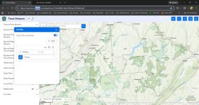
Screenshot 2025-11-08 094742.jpg

Has anyone actually got the filters working? Specifically, I was trying to filter CL-A streams based on fishery: Brook, Brown, Mixed Brook/Brown, etc. to see if I can limit returns but can't seem to get them to produce the results I'm looking for. Anyone using PA Trout Map ArcGIS filters and getting results?
 
I just tried mine. Seems to be working as it did last time I was on it.?
I’m able to filter class a, and nat produced, wilderness etc.
IDK, maybe something with your settings?
 
I just tried mine. Seems to be working as it did last time I was on it.?
I’m able to filter class a, and nat produced, wilderness etc.
IDK, maybe something with your settings?
Thx TH . I can certainly toggle the main categories off/on. I'm talking about going into each one of those and filter more specifically.

There's options in each one of them to select a specific attribute like fishery, stream name, GPS coordinates, etc and see just those things. That's want I can't seem to get working.

Are you able to filter at that level?
 
It does not work for me either. State Park filter works, but not stream info with text. The filter does work with numeric columns.

I exported to csv. Opened in Excel. Filtered in Excel.

Thanks for sharing your issue. I had not seen the updated maps and I din't think any data was available for export before.
 
I got this message on my phone
IMG_9650.jpeg

I clicked the link and it worked. Still has the free topo maps so that’s a plus. The old map works til April. Jeff you better get on the old one this winter and start memorizing some stuff 😉

~5footfenwick

Ps. To get to the old map you must click “I understand this map is being retired”
Joke is on them
I really don’t understand, did the old map just say it’s time to watch football and go fly fishing more, I need to retire?
 
For clarity, the old and new maps have toggles for "Class A Trout Stream", "Stocked Trout", "State Parks", etc. Those work on both ild and new.

The new maps have additional filters. For streams, if the filter data type is text, the filter does not work. If the filter data is type numeric, it works.

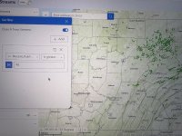
Here is a pic of all Class A Trout Streams filtered to only include streams that are >90% public land. I don't think the advanced filtering was a feature of the old map.

On the nee map, clicking on the ... next to the name, for example Class A Trout Streams, has an option to export the data to csv.

Here is csv file showing the different Fishery types.
IMG_3336.jpeg
 

Attachments

  • IMG_3335.jpeg
    IMG_3335.jpeg
    406.3 KB · Views: 34
Exactly what I needed Flyguy. Thank you! Great explanation and I didn't think to download the data as a .csv. I can work with that!
 
Exactly what I needed Flyguy. Thank you! Great explanation and I didn't think to download the data as a .csv. I can work with that!
If you are specifically wanting an interactive map format, QGIS is a free open source mapping software.

I’m no expert, but I played around with it for an afternoon and was able to upload the trout streams GIS data files (hosted on PASDA site I believe), and apply different layers/filters.

That produced a map which I filtered to show only Class A brook trout streams.
 
Back
Top