Reporting Mapping Errors

R

RLeep2

Well-known member
Joined
Oct 15, 2009
Messages
1,456
Even though I am unsure that this is the best sub-forum fit, I'll put this here to take advantage of the higher traffic. Mods feel free to move it as you see fit. If necessary, I'll get over it...:)

In a nutshell: I've found a pretty significant stream course location error in Google Maps that appears to have originated in the USGS topos. As would follow, the error also seems to be present in all the mapping applications that rely on Google or USGS or both for their information. In this case, that means Acme 2.1, the online PFBC maps and the Garmin/DeLorme print and online maps. These are the only additional places I've checked and are probably only the tip of the iceberg. Junk information shared at the speed of current technology simply becomes amplified junk information.

I've reported the error to Google, but while the notion may seem outdated and biased, I somehow do not see Google as the Supreme Court of Cartography and am not sure I trust them to understand the scope of the error and fix it.

What is ironic (at least to me..) is that the satellite view option on all the mapping applications clearly shows the correct information and the nature of the error.

Should I also inform the Feds (USGS) and folks like Garmin, Acme, etc? That is to say, serious people who are actually in the map accuracy business and not primarily concerned with delivering my email and the bells and whistles of my home page.

All wisdom welcomed..

Thanks
 
In the course of my work I find topographic map minor errors regarding stream courses from time to time., usually involving a short stretch of an otherwise accurately depicted stream. I rarely even find perennial streams that aren't shown. I ignor these unusual errors and forge ahead.
 
I have worked in an industry for the past 30 years where I have to use mapping of all kinds. Topographic, aerial photography, soil data and drainage basin information are all things that I use on a daily basis. Over the years I have noticed many errors in mapping that to us may seem glaring but in all reality are probably fairly minor. I do agree with you that with the fast pace of the electronic age many errors are replicated making the issue seem even bigger. It’s all at our fingertips now so it is easier to find. Back in the day you actually had to ground truth something to know that the mapping was not accurate. All in all, I kind of find it refreshing that everything is not pin point accurate, still gives us a reason to put some boots on the ground and do some exploring.
 
I'm curious what error you found.

I recommend reporting it to the USGS. Many other organizations use USGS as their base info.

I have seen many errors on Google Maps that are shown accurately on USGS maps. It is very common for Google Maps to show stream names wrong.

On AcmeMapper you can switch between street view, which is the same as Google Maps, and USGS topo maps.


OK. I'll attempt to illustrate the error by providing the map view and the satellite view of the area. This is not a fishing significant error. It just happens to be my home neck of the woods and the first time I looked at it in the PA DeLorme a long time ago, I knew it was wrong.

https://www.google.com/maps/@41.9309672,-79.980909,15z]map view

Notice the course of LeBoeuf Creek (the primary inlet of Lake LeBoeuf) at near center and notice where the named stream line suddenly shoots south to cross PA97 and connect with LeBoeuf Creek downstream/below Lake LeBoeuf. In reality, the stream does not cross PA97 but instead meanders north to cross US 19 just south of the Borough of Waterford and just north of the Google Map marker named TOPS Market. From there, it parallels Water Street and S. Hazel Street and then empties into Lake LeBoeuf.

https://www.google.com/maps/@41.9355072,-79.9848206,2561m/data=!3m1!1e3]satellite view

The satellite view of the same Google map shows the correct course and location of the stream. This can easily be seen when it is compared with the map view.

I hope these links work to illustrate what I found...


I don't know why the full urls won't copy/paste for me. They should still be viewable with a little effort if you re-copy/paste from my post.

On edit: The USGS topo map as viewed on Acme 2.1 shows the same error. I assume this is where all the rest came from.
 
^ I tried to fix your links to the map but cannot make it work with those links.

Like others have posted, minor mapping errors are quite common. Errors now become easier to detect and are more apparent since one now has the ability to view actual satellite images of the exact same area mapped out. A picture is worth a thousand words, I guess.....

Report the error if it is a major one.

 
Interesting subject. I fish ravines with a garmin etrex w garmin topo, and only once came across a memorable map versus reality difference... a tiny stream that is 200 ft steep descent from a road in reality but shown as 60 ft on map. Memorable because the map is usually so reliable. I looked at the usgs topo and it better reflects area in that one case.

For fishing, good to check latest online state maps given some ongoing additions to public land.
 
I believe the maps represent an accurate picture of the stream, but at a past point in time. The meander of the former channel of LeBeouf Creek is still visible in the satellite view and it looks like the stream went under 97 at one point. The 1967 24K base topo shows the stream going under 97, with a perennial meander to the west into LeBeouf Lake.

If you use the TopoView USGS mapping tool, it looks like the current basemap is correct.

https://ngmdb.usgs.gov/topoview/viewer/#15/41.9361/-79.9768

When print maps were the primary form of mapping data, companies would intentionally include mistakes in their maps. One of the reasons is they could then find out who was copying their data. If competitor X released a map and it had the same incorrect data on it, you knew your competitor was leveraging your data. With the USGS being a public organization, I don't think that is the case here.
 
As I said to a confused person just this past Friday looking for an incorrectly placed address on Google Maps: Google is often wrong, as are other sources, which is why I rely on several when creating routes, waypoints, etc.

That being said, the only outfit that actually made a correction on errors I've discovered was Garmin but that was when I discovered Garmin maps didn’t show the recently completed EZ Pass Only exit at Route 903 on the Northeast Extension.

Garmin has a process for reporting errors so I sent them the info & verification from the PA Turnpike Commission and they replied it would be corrected, which it was in the next mapping update.

HOWEVER, that was a road/exit error on an Interstate toll road, which would really **** off people using Garmin GPS units for routing. I have a feeling a stream course error would have resulted in crickets.

BTW - Feel free to thank me if your Garmin GPS doesn't send you the old way to Albrightsville or Pocono Raceway. ;-)

I’m with Mike, I’ve discovered a zillion stream course errors on Google, Garmin, USGS & Delorme. As long as I find the creek I am looking for, I could care less if anyone else can so I just forge ahead.
 
salmonoid wrote:
I believe the maps represent an accurate picture of the stream, but at a past point in time. The meander of the former channel of LeBeouf Creek is still visible in the satellite view and it looks like the stream went under 97 at one point. The 1967 24K base topo shows the stream going under 97, with a perennial meander to the west into LeBeouf Lake.

If you use the TopoView USGS mapping tool, it looks like the current basemap is correct.

https://ngmdb.usgs.gov/topoview/viewer/#15/41.9361/-79.9768

Good stuff.

I looked at satellite imagery on Acmemapper and you can see the relic channels of the former "southern route."

Erie County bayou country!!
 
I've lived within 10 miles of the place in question since 1952 (with the exception of the period from 1999 to 2014) and so far as I am aware, LeBoeuf Creek has always been exactly where it is now in relation to area roads. It certainly was that way in 1967.

All the same, interesting theories. I can't say that the creek never flowed in another channel (I'm old but not that old..). I'll research the pre-1960 period, but color me doubtful.

Thanks All..
 
Most of the USGS 7.5’ quads were originally done almost 100 years ago and then were updated via aerial photography (date usually in magenta on the map key. Streams change course over time, meanders migrate, floods open new channels, roads reroute, etc.

Write your congressman to fully fund useful geologic and topographic data through the USGS. All the global warming funding doesn’t replace solid fieldwork. Same goes for the now poorly funded PA Geologic Survey, a shadow of its former self.

At the end of the day a classic case of blackbox “poop data in, poop data out”
 
Working in the GIS field, these sorts of errors happen and are due to features being drawn from base maps that are different than the ones being used to view the information. Good for you to report it. Most mappers like to keep their data up to date.... (can't stress most enough) good info on the stream channel changing as well
 
I would add that unnamed tribs are being officially named on an ongoing basis. The PFBC, among other agencies I assume, is asked to review the proposed names and the reasoning behind them and the assignment falls on Area Fisheries Managers. Without annual updates to the mapping systems that you use today's unnamed trib that you are fishing or is so small that you use it to collect minnows may be tomorrow's (yet another) Mill Ck.

As odd as it may seem to some, that minor trib down the road that goes dry nearly every summer might actually have a name now or in the future yet the larger trib up the road that supports a year around fish population may remain nameless. It all pretty much depends on local interest and the willingness/persistence of proponents to jump through the bureaucratic hoops necessary to have a name assigned to a stream.

In most cases in SE Pa new names usually have to do with a historical property or its owner, or a locally, well-known individual who lived near-by.
 
troutbert wrote:
salmonoid wrote:
I believe the maps represent an accurate picture of the stream, but at a past point in time. The meander of the former channel of LeBeouf Creek is still visible in the satellite view and it looks like the stream went under 97 at one point. The 1967 24K base topo shows the stream going under 97, with a perennial meander to the west into LeBeouf Lake.

If you use the TopoView USGS mapping tool, it looks like the current basemap is correct.

https://ngmdb.usgs.gov/topoview/viewer/#15/41.9361/-79.9768

Good stuff.

I looked at satellite imagery on Acmemapper and you can see the relic channels of the former "southern route."

Erie County bayou country!!

I don't think I'm coughing any spots up by saying this, but that is a classic NW big brown trout type setting. There are streams up there that disappear into a swamp for a mile or two and where they flow into the swamp and upstream are nice 20" brownies. The streams are often alder or willow choked, and the nearest stocking point is a stream often five miles away. The fish are clearly of wild origin, but probably moved through the swamp during a high water event.

Regarding mapping errors, having drawn the lines on a number of geological maps, there are times where you don't have the field data to fully backup what you think the map should have on it. So you interpolate a bit - sometimes it works out, and sometimes, it's just a bad guess. In one case, I was working on heavy metal sediment distribution downstream of the Couer d'Alene mining district. I was drawing the countours on several 24K maps, but was not the one who collected the data, so I had to make guesses at some points where the contours might run. On another situation, I was working with a team in the field for a summer. We were mapping in the Belt Supergroup in Idaho and one of the curious features we encountered periodically was dubbed the Wallace Breccia. It showed up in the rock formations and we tried to figure out if there was any continuity between where it showed up at one location and where we might encounter it miles away. We ended up opting to just mark the map that was ultimately published with a symbol identifying where we encountered the feature in the field, rather than try to interpolate how it all might have been related by trying to connect the dots.
 
maps are great but can't be perfect ... OT but imagine the map- highway sign differences emerging with this:

http://6abc.com/traffic/explainer-why-parts-of-i-95-are-becoming-i-295/3601666/

ps salmonoid sent you a pm!
 
not sure how many maps it would affect, but as the (overly technical for me!) article below suggests, a major flood could cause a stream to erode channeling berms from the logging era and change its path:

https://pubs.geoscienceworld.org/gsa/geosphere/article/12/1/305/132296/geomorphic-response-to-catastrophic-flooding-in

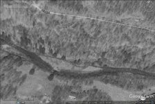
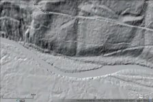
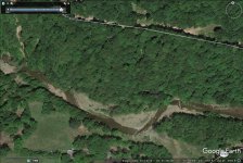
images are west branch fishing creek just upstream of central PA in 1994 black and white, 2007 or so gray-scale lidar contour map showing what appear to be channeling berms, and in 2016 (after the major 2011 flood)...

most of the channel had less change, I cherry picked a spot that looks very different. still might matter to some mappers.
 

Attachments

  • wbf94.jpg
    wbf94.jpg
    113.2 KB · Views: 1
  • wbf07L.jpg
    wbf07L.jpg
    92.3 KB · Views: 1
  • wbf16.jpg
    wbf16.jpg
    209 KB · Views: 1
k-bob wrote:
not sure how many maps it would affect, but as the (overly technical for me!) article below suggests, a major flood could cause a stream to erode channeling berms from the logging era and change its path:

https://pubs.geoscienceworld.org/gsa/geosphere/article/12/1/305/132296/geomorphic-response-to-catastrophic-flooding-in

images are west branch fishing creek just upstream of central PA in 1994 black and white, 2007 or so gray-scale lidar contour map showing what appear to be channeling berms, and in 2016 (after the major 2011 flood)...

most of the channel had less change, I cherry picked a spot that looks very different. still might matter to some mappers.


Thanks for posting the study. It's very interesting.

It's too bad they didn't study Mehoopany Creek and tribs. There were some really extreme changes in that watershed.
 
Check out this change that resulted from the Sept. 2011 flood.

Big Bear Creek or Dunwoody Road?

https://www.youtube.com/watch?v=csbV3vHbxQU


Back
Top