R
RLeep2
Well-known member
- Joined
- Oct 15, 2009
- Messages
- 1,456
Even though I am unsure that this is the best sub-forum fit, I'll put this here to take advantage of the higher traffic. Mods feel free to move it as you see fit. If necessary, I'll get over it...")
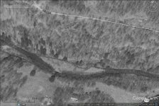
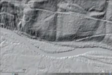
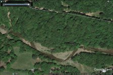
In a nutshell: I've found a pretty significant stream course location error in Google Maps that appears to have originated in the USGS topos. As would follow, the error also seems to be present in all the mapping applications that rely on Google or USGS or both for their information. In this case, that means Acme 2.1, the online PFBC maps and the Garmin/DeLorme print and online maps. These are the only additional places I've checked and are probably only the tip of the iceberg. Junk information shared at the speed of current technology simply becomes amplified junk information.
I've reported the error to Google, but while the notion may seem outdated and biased, I somehow do not see Google as the Supreme Court of Cartography and am not sure I trust them to understand the scope of the error and fix it.
What is ironic (at least to me..) is that the satellite view option on all the mapping applications clearly shows the correct information and the nature of the error.
Should I also inform the Feds (USGS) and folks like Garmin, Acme, etc? That is to say, serious people who are actually in the map accuracy business and not primarily concerned with delivering my email and the bells and whistles of my home page.
All wisdom welcomed..
Thanks