WildTroutStreams.com: The Next Generation

wtsobsessed

wtsobsessed

Member
Joined
Mar 11, 2011
Messages
40
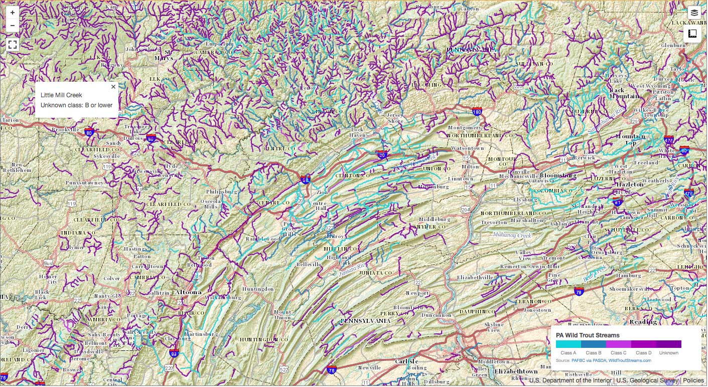
The next generation of WildTrouStreams.com no longer requires you to download any files. If you have a fast internet connection, an HTML 5 compatible browser (IE 9+, or recent versions of Firefox, Chrome, or Safari) and (ideally) a big screen, you can view a detailed map of PA that contains information about all of the streams holding wild trout, plus a lot of additional information.

You can find it here: PA Wild Trout Streams

This is still a pilot implementation. Right now, for example, there's no good way to print a map... I'm hoping to provide some additional features like that, and the ability to export markers.

Please let me know what you think.

pa-screenshot.jpg


Thanks, this one is much easier to use. It's on my favorites list. I like being spooned, it makes finding those gemmies a lot easier. Wait, I promised myself I'd never use that silly term. Oh well.
 
Thanks for this map.

One thing I noticed is that Penns Creek is shown as being Class A far below Cherry Run, below Weikert, even down past Pardee.

This is stocked water.
 
wildtrout2 wrote:
Thanks, this one is much easier to use. It's on my favorites list. I like being spooned, it makes finding those gemmies a lot easier. Wait, I promised myself I'd never use that silly term. Oh well.

You have ore to worry about than gemmies... LOL. [spooned] :-D

I'd like to by an F for $400.

 
I looked at this a little more and found some others that appear to be errors.

These Class A listings I'm pretty sure are incorrect:

Sinn Portage Creek, headwaters to mouth.

Driftwood Branch Sinn Creek, headwaters down to 300 meters above the Route 120 bridge in Emporium.

Freeman Run, headwaters to mouth.


troutbert wrote:
I looked at this a little more and found some others that appear to be errors.

These Class A listings I'm pretty sure are incorrect:

Sinn Portage Creek, headwaters to mouth.

Driftwood Branch Sinn Creek, headwaters down to 300 meters above the Route 120 bridge in Emporium.

Freeman Run, headwaters to mouth.
Freeman Run CONFL POSTALWEIGHT HW downstream to CONFL BARK SHANTY HW

Driftwood Branch Headwaters to Elk Fork, Sinn Portage Creek Parker Run downstream to Cowley Run.
 
The Class A streams data comes straight off of PAFBC's most recent GIS data which is available from PASDA. I joined the Trout Natural Reproduction dataset with the Class A to merge the data, but that's very straight forward, and should not introduce any classification errors.

I'm pretty sure that if there are errors in the stream classification boundaries, they're in PAFBC's original Class A dataset. You may want to send your comments to them.
 
>>I'm pretty sure that if there are errors in the stream classification boundaries, they're in PAFBC's original Class A dataset. You may want to send your comments to them.>>

Well, if you say so...

All I know is that however it is that you've hooked the clutch up to the flywheel and zurbled the microphaser to align with the merging of the various datasets, it has produced numerous errors that manifest themselves in your map. Just as a cursory glance, it appears that at least part of what is going on is that your product as currently configured seems to be (in some, but certainly not all cases..) pulling any designation that PFBC has placed on a specific stream section and applying this same designation to the entire stream. There are the examples that Chaz and Troutbert have noted (I've found several more of these..) and there are also some situations where your map seems to be pulling PFBC biomass class designations from a single stream section on the Wilderness Streams List and applying them to the entire stream.

None of this is criticism. This is a major endeavor you've undertaken.

I'm just telling you that there are a lot of errors and that these errors are not also found in the matching PFBC information available online. Bear in mind that I'm talking about stuff I can see and read online. I wouldn't know if the Commission has over zurbled their dataset microphaser and as a result is feeding you junk. That's a different issue and way over my pay grade...

I only know that your map as it stands is quite an accomplishment, but it still has a pretty fair ways to go before it can be said to be accurate.
 
RLeeP is correct.

If you Google "PFBC Class A" you will bring up their Class A list, and this shows the info correctly for the streams I mentioned.

These streams do have Class A sections. But on your map, the Class A line is extended downstream much further than it should be, into sections that are definitely not Class A.

How and why this happened, I don't know. Database "stuff" happens.
 
1. What is the difference between Class A and Class B?
2. What do the different shades of blue mean in the "habitat" layer?
 
As another example,

Little Fishing Creek: Centre County. Map says class A headwaters to Roaring Run. PFBC class A list says "SPRING 6.8KM UPST T420 BRIDGE downstream to 1.2KM DNST T470 BRDG MINGOVILL", which is a much shorter stretch contained within what the map says.

Or Willow Creek: Berks County. Map says class A headwaters to mouth. PFBC list says "375 M UPST T-707 BRIDGE downstream to MOUTH", which is a small stretch near the mouth. Upstream, it's not only not class A, but it's ATW and stocked heavily.

In addition, it has entire streams listed as class A that are not class A anywhere.

Example: Swift Run - tributary to Penns. Map says it's class A headwaters to mouth. It's class A NOWHERE.

A nearby example of the reverse:

Cherry Run - tributary of Penns. Map says it's class B headwaters to mouth. In reality, it's class A in it's lower end.

Another gripe. In places where it is indeed class A, but the fish commission lists no data on %public/%private, this map calls it 100% private. In many cases, this isn't true, as some does fall on public land, the PFBC merely didn't list the data. It's like with a lack of data supplied the map assumes it to be private.

As was stated, this isn't meant to attack what you've done, it's meant to be constructive. It's a VERY good tool, it's just not quite there yet. The details matter to us. The biggest thing this looks to add for us is a distinction between class B, C, and D, which was not available publicly before.

 
pcray1231 wrote:
As another example,

Little Fishing Creek: Centre County. Map says class A headwaters to Roaring Run. PFBC class A list says "SPRING 6.8KM UPST T420 BRIDGE downstream to 1.2KM DNST T470 BRDG MINGOVILL", which is a much shorter stretch contained within what the map says.

In addition, it has entire streams listed as class A that are not class A anywhere.

Example: Swift Run - tributary to Penns. Map says it's class A headwaters to mouth. It's class A NOWHERE.

A nearby example of the reverse:

Cherry Run - tributary of Penns. Map says it's class B headwaters to mouth. In reality, it's class A in it's lower end.

Another gripe. In places where it is indeed class A, but the fish commission lists no data on %public/%private, this map calls it 100% private. In many cases, this isn't true, as some does fall on public land, the PFBC merely didn't list the data. It's like with a lack of data supplied the map assumes it to be private.

As was stated, this isn't meant to attack what you've done, it's meant to be constructive. It's a VERY good tool, it's just not quite there yet. The details matter to us. The biggest thing this looks to add for us is a distinction between class B, C, and D, which was not available publicly before.

Swift Run was proposed here:
http://www.pabulletin.com/secure/data/vol44/44-9/453.html

The PDF of Class A's is dated December 31, 2013, and it doesn't contain Swift, but I assume the GIS data is newer than that and does; at least the PASDA PFBC shows Swift as Class A.

 
Oh man, All I know is that if anyone goes to a stream expecting it to be class A and you find it to be the inferior class B, you should be pissed. :lol:

I'm just messing with you.

If you see errors, tell the fish commission so they can fix them. It's what computer weenies do.

Seriously though, they'd likely appreciated the comments.
 
Thanks salmonoid, did not know that Swift was to be added to the class A list. That solves one of them. It doesn't change the rest.

Oh man, All I know is that if anyone goes to a stream expecting it to be class A and you find it to be the inferior class B, you should be pissed.

Or in some of these cases, class C, D, or not having wild trout at all, or even being full of stocked trout.

Pissed is a strong word. But we'd use a map like this as a scouting tool to point us towards good water that we don't yet know. When you see glaring errors on waters you do know, you tend not to trust it enough to use it for it's intended use.

Many of my favorites are actually class C, and I tend to look for B's and C's over A due to lower crowds and often better fishing.

Again, we're trying to help, not attack.
 
wtsobsessed wrote:
... I joined the Trout Natural Reproduction dataset with the Class A to merge the data, but that's very straight forward, and should not introduce any classification errors.

Given the evidence so far presented, it seems entirely possible that the merge is not as straight forward as you thought.

Is the merge an xsl transform?
 
Nice map. When will other states be available?
 
Thanks for the cool, free site. Some very nice layers - public land, hiking trails - and a nice tool at upper left to measure distance. Good base map selection, I like the street one...

People who'd use this site will probably also use other maps, sites, and books, and maybe phone apps or gps, so no one source has to do everything. (For example, even if a website has the natural reproduction list streams mapped precisely, the unassessed stream projects are finding many streams with ST that aren't on that list.)

This site gives a lot of info quickly, thanks again.
 
salmonoid wrote:
pcray1231 wrote:
As another example,

Little Fishing Creek: Centre County. Map says class A headwaters to Roaring Run. PFBC class A list says "SPRING 6.8KM UPST T420 BRIDGE downstream to 1.2KM DNST T470 BRDG MINGOVILL", which is a much shorter stretch contained within what the map says.

In addition, it has entire streams listed as class A that are not class A anywhere.

Example: Swift Run - tributary to Penns. Map says it's class A headwaters to mouth. It's class A NOWHERE.

A nearby example of the reverse:

Cherry Run - tributary of Penns. Map says it's class B headwaters to mouth. In reality, it's class A in it's lower end.

Another gripe. In places where it is indeed class A, but the fish commission lists no data on %public/%private, this map calls it 100% private. In many cases, this isn't true, as some does fall on public land, the PFBC merely didn't list the data. It's like with a lack of data supplied the map assumes it to be private.

As was stated, this isn't meant to attack what you've done, it's meant to be constructive. It's a VERY good tool, it's just not quite there yet. The details matter to us. The biggest thing this looks to add for us is a distinction between class B, C, and D, which was not available publicly before.

Swift Run was proposed here:
http://www.pabulletin.com/secure/data/vol44/44-9/453.html

The PDF of Class A's is dated December 31, 2013, and it doesn't contain Swift, but I assume the GIS data is newer than that and does; at least the PASDA PFBC shows Swift as Class A.
TB says that Swift Run is not Class A until it gets lower in the watershed because of high acidity, intact there are no trout above that trip. So if you go there you will find brookies further down, I saw them myself. But data don't lie though, when you go fishing it's all about the conditions, i.e., if you go to a Class

A stream you may find the fishing lousy, chances are the fishing will be lousy anywhere in that area. In many cases it's weather related, conditions that trump the status of the population. But if you go out in May and fish any Class A stream the second after a cold front goes through, the chance of good fishing are excellent.
 
I've fished Swift once or twice, and caught fish, but it wasn't real good. That said, that was a long time ago. Not only didn't I fish the whole thing, but also things change, and as you said, fishing may not be the best sampling method.

So good to know it's going class A somewhere, and I wasn't doubting the info.

So that's an example where the new map had info that was more up to date than the info I have.

But the other examples still fit. I don't think ALL of those areas turned class A, lost class A status, became private, etc.

The point was that the map still has a lot of errors.

Again, I'm pointing it out to help, not criticize, because it has the makings of an excellent resource. If we can point out exactly where there are issues, perhaps it will lead to an understanding of how the issues came to be, and thus a solution.
 
As another example, Penns Creek itself. Map shows it class A from headwaters to well below Weikert.

It's not class A till it reaches Coburn. From Spring Mills to Coburn its stocked. And below Weikert it's not class A either, it's stocked there as well.
 
Back
Top