Poe Paddy Tunnel Repairs

McSneek

McSneek

Well-known member
Joined
Apr 12, 2011
Messages
2,297
http://www.prnewswire.com/news-releases/construction-to-begin-at-poe-paddy-tunnel-along-penns-creek-300060893.html

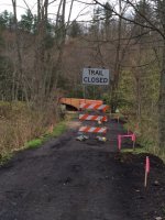
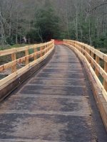
Saw this on the Jamboree thread and thought it should go in this forum. Nice that the tunnel will be repaired and made safer but doing it at this time of year sure is a head scratcher.

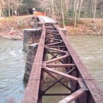
I have gone "up and over" a few times after the tunnel was closed off but eventually decided to just risk walking through the tunnel to save time and effort. Looks now like even the bridge across the creek will be closed at some point.

My question is, where else can you park and access the upper end of the C&R stretch? I know there's the lot at Poe Paddy campground but that is still pretty far above the C&R section, isn't it? Is there parking/access if you drive down Paddy Mtn. Road towards the mouth of Swift Run?

Anyone know if anything is being done to help fisher persons access the C&R stretch from the upper end?
 
Is there parking/access if you drive down Paddy Mtn. Road towards the mouth of Swift Run?

Yes, but not much. It's pretty much side of road parking down there. I've done it before, and I'm guessing a lot of people will do it now. Just note that there's a private camp there, and be smart about where you park. I foresee trouble.

You can also likely drive around and park at Cherry Run and walk up. Though they are saying that the trail will be under heavy construction as well (basically turning it into a road to haul heavy equipment), so be careful. That's not a real long walk if you have the trail, but if you're doing it on the other side it's a bit tougher.

In the end, it's a perfect storm for access on Penns. The access at Coburn to go down got posted, and the downstream access from Poe Paddy is gonna be a mess this year.
 
When I was there in the fall I kinda scouted that out and there is limited parking along the fireroad out of Poe Paddy beteen Panther & Swift Run that some fellas were using. Otherwise, as the song says, "those boots were made for walkin'" and it really isn't that bad of stroll down from Poe Paddy.
 
be a good year to head over to fishing creek!
 
Time to explore the Ingleby section.
 
pcray1231 wrote:
You and everyone else......

Wouldn't surprise me if all the traffic being pushed to other areas increases private land owner friction similar to that near Coburn. Everyone should take extra care.
 
Ingleby is fished out, don't even bother.
 
I will be camping at Poe Paddy Wednesday through Sunday of next week and I can't wait. I am praying for reasonable flows on Penns.

So, I was wondering if anyone had actually laid eyes on the Trestle Bridge or tunnel recently. I read all the details of the OP, but sometimes reality can be a bit different.

Additionally, I was wondering the status of the Grannom and Hendrickson hatches through the project water. It appears that everything is a bit in dealy this year and I am thinking we may hit the Grannoms in their peak.

Your thoughts?
 
Haven't been to Penns yet this year, so I can't say (saving all my domestic points for hopefully a LONG jam trip in mid-May).

Yeah, hatches are late so far, and then the weather broke suddenly, so they'll be trying to catch back up. Whether it's grannoms or Hendricksons or something else, that bodes well for you, as you could be getting hatches that were supposed to be done, combined with ones that are supposed to be on, combined with ones that should just be starting up.

I'm not sure what the rain's been like up there. Around here, it's rained virtually every day for the last two weeks, but grand total is about a tenth of an inch, lol. Just light drizzles and spitting a bit nonstop, but never deciding it's gonna come down on us. It's kinda funny when you look at dark green/yellow/red blobs on radar sitting on top of you, then look outside and the driveway is dry, but hey, there's a few beads of water on the car, so yeah, it's technically "raining".
 
Flows are reasonable right now at 780 cfs, we will just need to dodge any bullets for the next 9 days which can always be the challenge this time of year.

Pat, I sure am hoping your hatch prediction is right! Last year it seemed to take longer into April than expected for the residents to remember how to rise.
 
Picture of bridge from Saturday, April 11th.


Attachments

  • Bridge Improvement - 11APR2015.jpg
    Bridge Improvement - 11APR2015.jpg
    112.1 KB · Views: 3
Well, I was giving my optimistic thoughts on the bugs. The fish, well, it's Penns, so who knows?
 
Luke wrote:
Picture of bridge from Saturday, April 11th.

So the brave or foolhardy can still cross there, walk around the fencing and through the tunnel. No problem!

Tough to be the folks who own those cabins on each side of the tunnel mouth.
 
haha, I wouldn't cross that bridge.

That said, at decent flows, it's not THAT hard to wade across the stream just up from the bridge. It's also not that hard to go over the hill.
 
Sitting here at work, watching in frustration as the Penns Creek water height continues to rise and rise and rise.

About 1,250 cfs.

I can just picture the chocolate milk.
 
Luke wrote:
Sitting here at work, watching in frustration as the Penns Creek water height continues to rise and rise and rise.

About 1,250 cfs.

I can just picture the chocolate milk.

Yikes! I'm never going to get up there this spring. I fished Muddy Creek in York Co. for a few hours mid-day yesterday. It was in desperate need of a shot of rain. Last night and this morning's rain could only help down this way. Hard to believe how much more water there is roughly 130 miles away.
 
Was up there today. A lot of work going on on the downstream side of the tunnel. Many work vehicles in and out. Lots of construction sounds. Stopped to check progress on the bridge when I left. Still closed. New railing installed but temporary flooring. Tried to post picture from iPad. I'll do it from computer tomorrow. Nice to see they're working to get the tunnel open again
 
Trying again with the photos.
 

Attachments

  • Tunnel2.JPG
    Tunnel2.JPG
    115.6 KB · Views: 4
  • Tunnel1.JPG
    Tunnel1.JPG
    103 KB · Views: 4
Back
Top